iAspirants
Africa's Geological Transformation Explained
Published on:
Share this post
Article Summary
Geological Transformation in Africa: Key Highlights
Geological Process:
- Africa is undergoing a significant geological transformation that could separate the continent into two distinct landmasses.
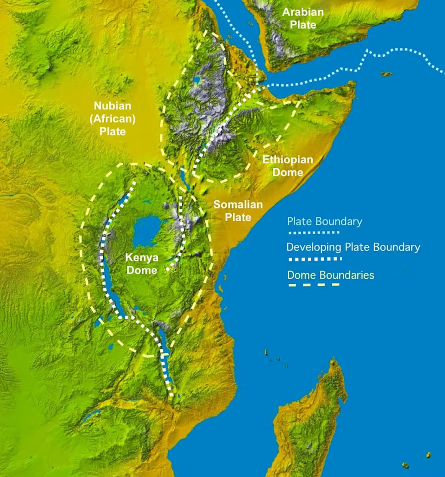
- The ongoing rifting is progressing from the northeast toward the south, potentially leading to the formation of a new ocean.
Timeframe of Separation:
- The complete split is projected to occur within the next 5 to 10 million years.
Future Geography:
- Post-separation:
- Western Landmass: Major nations like Egypt, Algeria, Nigeria, Ghana, and Namibia.
- Eastern Landmass: Includes Somalia, Kenya, Tanzania, Mozambique, and parts of Ethiopia.
- Post-separation:
Plate Tectonics Theory:
- The transformation is rooted in the theory of plate tectonics, indicating that Earth's continents constantly shift over time.
- Tectonic plates fracture and drift, leading to the creation of new oceanic crust through seafloor spreading.
East African Rift:
- A significant tectonic fissure approximately 4,000 miles long, stretching from Jordan through eastern Africa to Mozambique.
- Measures around 30 to 40 miles in width, indicating zones where the crust is thinning and pulling apart.
Key Research Areas:
- The Afar region, where three rift systems converge: Main Ethiopian Rift, Red Sea Rift, and Gulf of Aden Rift. This area exhibits the most visible early signs of continental breakup.
Historical Data Analysis:
- Researchers analyzed magnetic data from the 1968-1969 Afar Survey using modern techniques to uncover new insights.
- The reinterpreted magnetic data revealed evidence of ancient seafloor spreading between Africa and Arabia.
Evidence of Slow Rifting:
- The crust in this region is gradually thinning and stretching, marking the future formation of a new ocean basin.
- Current rifting rates are estimated at approximately 5 to 16 millimeters per year in the northern rift segment.
Scientific Implications:
- Published findings in the Journal of African Earth Sciences emphasize the importance of the Afar region in understanding continental breakup.
- The data from historic surveys have been revitalized to support further analysis of geological processes.
Geological Significance:
- The study enhances our knowledge of continental shifts and highlights the slow yet powerful forces reshaping the Earth's surface.
This geological transformation not only illustrates the dynamic nature of Earth's surface but also reflects the potential socio-economic changes in the affected regions as new landmasses emerge over millions of years.
Key Terms & Concepts
| Afar region | location of continental breakup |
| East African Rift | zone of tectonic activity |
| Red Sea | converging rift system |
| Gulf of Aden | converging rift system |
| Lake Malawi | affected lake by split |
| Lake Turkana | affected lake by split |
| Journal of African Earth Sciences | publication of findings |
| 5 to 16 millimeters per year | current rifting speed |
| 1968 and 1969 | years of magnetic data collection |
| theory of plate tectonics | framework for geological transformation |
| millions or billions of years | geological time scale |
| seafloor spreading | process forming new oceanic crust |