iAspirants
NISAR Satellite Enters Science Phase
Published on:
Share this post
Article Summary
NISAR Satellite Mission Highlights:
Launch and Development:
- The NASA-ISRO Synthetic Aperture Radar (NISAR) satellite was launched on July 30, 2025, from the Satish Dhawan Space Centre, Sriharikota.
- It is the first satellite developed jointly by the Indian Space Research Organisation (ISRO) and NASA.
Phases of NISAR Mission:
- The mission is categorized into distinct phases: Launch, Deployment, Commissioning, and Science.
- The Science Phase commenced following the commissioning phase and will continue until the end of the satellite's five-year mission.
Satellite Specifications:
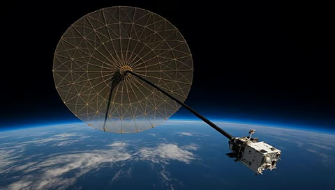
- The satellite features a 12-meter diameter antenna reflector crucial for both ISRO's S-Band and NASA's L-Band Synthetic Aperture Radar (SAR) Payloads.
- The antenna was deployed from a 9-meter long boom developed by NASA.
Operational Aspects:
- The operational science orbit will be maintained through regular maneuvers, which will aim to minimize conflicts with scientific observations.
- Extensive calibration and validation activities will be ongoing during this phase.
Data Acquisition:
- The first image acquisition occurred on August 19, 2025, with S-Band SAR regularly imaging the Indian landmass and various global calibration-validation sites.
- Reference targets have been deployed in locations such as Ahmedabad, Gujarat, to aid in image calibration.
Application Potential:
- Initial analyses show the potential of S-Band SAR data for multiple scientific areas including:
- Agriculture
- Forestry
- Geo-sciences
- Hydrology
- Polar and Himalayan ice/snow studies
- Oceanic studies
- Initial analyses show the potential of S-Band SAR data for multiple scientific areas including:
Calibration Sites:
- Data acquired from the Amazon rainforest has been utilized for calibrating spacecraft pointing and image quality.
By highlighting its interdisciplinary benefits, the NISAR satellite represents a significant step in Earth observation technology and international collaboration between India and the USA. Its findings are expected to hold implications for various scientific research and environmental monitoring efforts.
Key Terms & Concepts
| NASA ISRO Synthetic Aperture Radar (NISAR) | Earth observation satellite |
| July 30, 2025 | Launch date |
| Satish Dhawan Space Centre | Launch location |
| 12-meter diameter antenna reflector | Key component for radar |
| August 15, 2025 | Antenna deployment date |
| August 19, 2025 | First image acquisition date |
| Ahmedabad, Gujarat | Calibration target location |
| Amazon rainforests | Calibration data source |
| five-year mission life | Mission duration |
| agriculture, forestry, geo-sciences, hydrology, polar/Himalayan ice/snow, oceanic studies | Targeted science areas |